As a former teacher, I have 11 years’ worth of lesson plans that I am slowly rolling out that I want to share with you. Most of them below are free for you to use, but some are paid.
All of them are based on the 2004, 2008, and 2012 Virginia Standards of Learning (SOLs).
I also enjoyed teaching Civics and Economics, as well as Government, and am slowly adding my plans. One unit I was able to shoehorn into my teaching was The Stock Market Game. I taught those courses for about 6 years.
At one point, I was scheduled to teach AP Psychology, but that fell through. I ended up with some limited lesson plans.
Lesson Plans World History II SOL 6b: Absolute Monarchs
Standard WH II: Lesson Plans World History II SOL 6b:The student will demonstrate knowledge of scientific, political, economic, and religious changes during the sixteenth, seventeenth, and eighteenth centuries by
Objectives
SOL 6b) describing the Age of Absolutism, including the monarchies of Louis XIV and Peter the Great.
Lesson Plans
Introduction: A Bell-ringer activity
Notes: Students copy-down and discuss teacher generated notes
Activities: Students complete various in class activities to support learning including video analysis, maps, charts, diagrams, graphic organizers, worksheets, text-book questions, group discussion, KWL Charts etc.
Assessment: Informal, Formal, Exit-Questions, Teacher Questioning. Quizzes, Tests, Projects
Essential Knowledge: Characteristics of absolute monarchies
• Centralization of power
• Concept of rule by divine right Absolute monarchs
• Louis XIV of France: Palace of Versailles as a symbol of royal power
• Peter the Great of Russia: Westernization of Russia
Note 1: There is a good A&E/Biography Channel Video Biography of Louis XIV out there.Note 2: The above activities are best used with the Virginia Prentice Hall World History: The Modern Era textbook.
Lesson Plans World History II SOL 6a: Scientific Revolution
Standard WH II: The student will demonstrate knowledge of scientific, political, economic, and religious changes during the sixteenth, seventeenth, and eighteenth centuries by
Objectives: SOL 6a) describing the Scientific Revolution and its effects.
Lesson Plans
Introduction: A Bell-ringer activity
Notes: Students copy-down and discuss teacher generated notes
Activities: Students complete various in class activities to support learning including video analysis, maps, charts, diagrams, graphic organizers, worksheets, text-book questions, group discussion, KWL Charts etc.
Assessment: Informal, Formal, Exit-Questions, Teacher Questioning. Quizzes, Tests, Projects Essential Knowledge: Pioneers of the scientific revolution
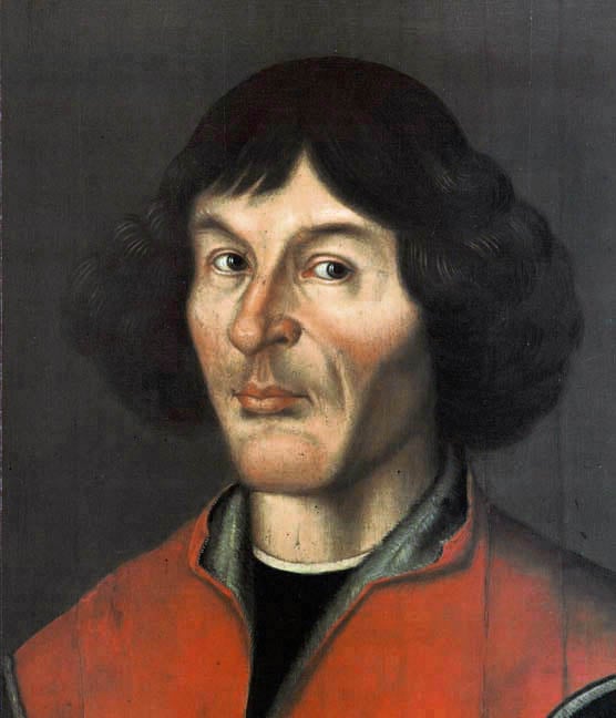
• Nicolaus Copernicus developed heliocentric theory.
• Johannes Kepler discovered planetary motion.
• Galileo Galilei used telescope to support heliocentric theory.
• Isaac Newton formulated law of gravity.
• William Harvey discovered circulation of the blood.
Importance of the scientific revolution
• Emphasis on reason and systematic observation of nature
• Formulation of the scientific method
• Expansion of scientific knowledge
Lesson Plans World History II SOL 5a,b,c,d: Impact of Europeans on East Asia, Africa, India, and Ottomans
Standard WH II: The student will demonstrate knowledge of the status and impact of global trade on regional civilizations of the world after 1500 A.D. (C.E.) by
Objectives
SOL 5a) describing the location and development of the Ottoman Empire.
SOL 5b) describing India, including the Mughal Empire and coastal trade.
SOL 5c) describing East Asia, including China and the Japanese shogunate.
SOL 5d) describing Africa and its increasing involvement in global trade.
Lesson Plans
Introduction: A Bell-ringer activity
Notes: Students copy-down and discuss teacher generated notes
Activities: Students complete various in class activities to support learning including video analysis, maps, charts, diagrams, graphic organizers, worksheets, text-book questions, group discussion, KWL Charts etc.
Assessment: Informal, Formal, Exit-Questions, Teacher Questioning. Quizzes, Tests, Projects Essential Knowledge:
SOL 5a:
Original location of the Ottoman Empire
• Asia Minor
Expansion and extent of the Ottoman Empire
• Southwest Asia
• Southeastern Europe, Balkan Peninsula
• North Africa
Development of the Ottoman Empire
• Capital at Constantinople renamed Istanbul
• Islamic religion as a unifying force that accepted other religions
• Trade in coffee and ceramics
SOL 5b:
Location of the Mughal Empire
• North India
Contributions of Mughal rulers
• Spread of Islam into India
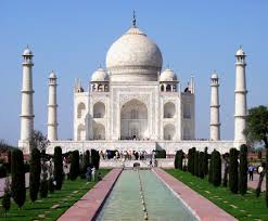
• Art and architecture: Taj Mahal
• Establishment of European trading outposts)
• Influence of Indian textiles on British textile industry
Trade with European nations
• Portugal, England, and the Netherlands competed for the Indian Ocean trade by establishing coastal
ports on the Indian sub-continent.
• Southern India traded silks, spices, and gems.
SOL 5c:
China
• Creation of foreign enclaves to control trade
• Imperial policy of controlling foreign influences and trade
• Increase in European demand for Chinese goods (tea, porcelain)
Japan
• Characterized by a powerless emperor controlled by a military leader (shogun)
• Adopted policy of isolation to limit foreign influences
SOL 5d:
African exports
• Slaves (triangular trade)
• Raw materials (ivory, gold)
African imports
• Manufactured goods from Europe, Asia, and the Americas
• New food products (corn, peanuts)
Lesson Plans World History II SOL 4e and 4f: Atlantic Slave Trade
Standard WH II: The student will demonstrate knowledge of the impact of the European Age of Discovery and expansion into the Americas, Africa, and Asia by
Objectives: e) mapping and explaining the triangular trade;
f) describing the impact of precious metal exports from the Americas.
Lesson Plans
Introduction: A Bell-ringer activity
Notes: Students copy-down and discuss teacher generated notes
Activities: Students complete various in class activities to support learning including video analysis, maps, charts, diagrams, graphic organizers, worksheets, text-book questions, group discussion, KWL Charts etc.
Assessment: Informal, Formal, Exit-Questions, Teacher Questioning. Quizzes, Tests, Projects Essential Knowledge:
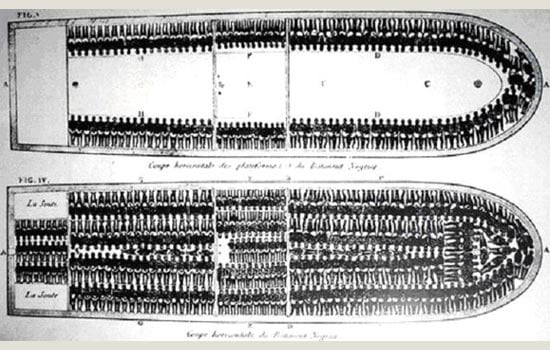
SOL 4e and 4f The triangular trade linked Europe,
Africa, and the Americas. Slaves, sugar,
and rum were traded.
Export of precious metals
• Gold and silver exported to Europe
and Asia
• Impact on indigenous empires of the
Americas
• Impact on Spain and Intentional trade
Tobacco Economy and Slave Life Analysis Tobacco Economy and Slave Life Analysis for use also with Tobacco Economy video hosted at the Jamestown-Yorktown Foundation: http://www.historyisfun.org/video/tobacco-economy/ Note: With the above Tobacco Economy activities I only use the document analysis portion comparing slave life with that of the slave-master.e
Lesson Plans World History II SOL 4d: Columbian Exchange
Standard WH II:
The student will demonstrate knowledge of the impact of the European Age of Discovery and expansion into the Americas, Africa, and Asia by
Objectives
SOL 4d) describing the Columbian Exchange, including its impact on native populations.
Lesson Plans
Introduction: A Bell-ringer activity
Notes: Students copy-down and discuss teacher generated notes
Activities: Students complete various in class activities to support learning including video analysis, maps, charts, diagrams, graphic organizers, worksheets, text-book questions, group discussion, KWL Charts etc.
Assessment: Informal, Formal, Exit-Questions, Teacher Questioning. Quizzes, Tests, Projects Essential Knowledge:
Columbian Exchange
• Western Hemisphere agricultural
products, such as corn, potatoes, and
tobacco, changed European lifestyles.
• European horses and cattle changed
the lifestyles of American Indians.
• European diseases, such as smallpox,
killed many American Indians.
Impact of the Columbian Exchange
• Shortage of labor to grow cash crops
led to the use of African slaves.
• Slavery was based on race.
• European plantation system in the
Caribbean and the Americas destroyed
indigenous economics and damaged
the environment.
Lesson Plans World History II SOL 4b, 4c: Age of Discovery; Age of Exploration
Standard WH II:
The student will demonstrate knowledge of the impact of the European Age of Discovery/ Age of Exploration and expansion into the Americas, Africa, and Asia by
Objectives
SOL 4b) describing the influence of religion.
SOL 4c) explaining migration, settlement patterns, cultural diffusion, and social classes in the colonized areas.
Lesson Plans
Introduction: A Bell-ringer activity
Notes: Students copy-down and discuss teacher generated notes
Activities: Students complete various in class activities to support learning including video analysis, maps, charts, diagrams, graphic organizers, worksheets, text-book questions, group discussion, KWL Charts etc.
Assessment: Informal, Formal, Exit-Questions, Teacher Questioning. Quizzes, Tests, Projects
Essential Knowledge:
SOL 4b: Means of diffusion of Christianity
• Migration of colonists to new lands
• Influence of Catholic and Protestant colonists, who carried their faith, language, and cultures to new lands
• Conversion of indigenous peoples
SOL 4c
Americas
• Expansion of overseas territorial claims and European emigration to North and South America
• Demise of Aztec and Inca Empires
• Legacy of a rigid class system and dictatorial rule in Latin America
• Forced migration of Africans who had been enslaved
• Colonies’ imitation of the culture and social patterns of their parent countries Africa
• European trading posts along the coast
• Trade in slaves, gold, and other resources Asia
• Colonization by small groups of merchants (India, the Indies, China)
• Influence of trading companies (Portuguese, Dutch, British)
Lesson Plans World History II SOL 4a: Age of Exploration; Age of Discovery
Standard WH II 4
The student will demonstrate knowledge of the impact of the European Age of Discovery and expansion into the Americas, Africa, and Asia by
Objectives 4a) explaining the roles and economic motivations of explorers and conquistadors.Standard WH II: Lesson Plans
Introduction: A Bell-ringer activity
Notes: Students copy-down and discuss teacher generated notes
Activities: Students complete various in class activities to support learning including video analysis, maps, charts, diagrams, graphic organizers, worksheets, text-book questions, group discussion, KWL Charts etc.
Assessment: Informal, Formal, Exit-Questions, Teacher Questioning. Quizzes, Tests, Projects Essential Knowledge: Factors contributing to the European discovery of lands in the Western Hemisphere
• Demand for gold, spices, and natural resources in Europe
• Support for the diffusion of Christianity
• Political and economic competition between European empires
• Innovations of European and Islamic origins in navigational arts
• Pioneering role of Prince Henry the Navigator
Establishment of overseas empires and decimation of indigenous populations
• Portugal: Vasco da Gama
• Spain: Christopher Columbus, Hernando Cortez, Francisco Pizarro, Ferdinand Magellan
• England: Francis Drake
• France: Jacques Cartier
Lesson Plans World History II SOL 3a, 3b, 3c: Reformation, Counter-Reformation, and Printing Press
Standard WH II: The student will demonstrate knowledge of the Reformation in terms of its impact on Western civilization by
Objectives:
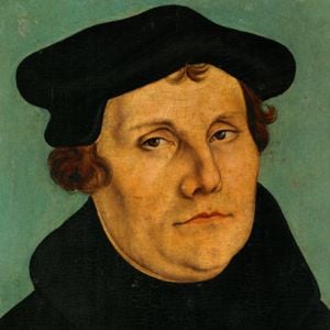
SOL 3a: explaining the effects of the theological, political, and economic differences that emerged, including the views and actions of Martin Luther, John Calvin, Henry VIII, and Elizabeth
SOL 3b: describing the impact of religious conflicts, the Inquisition, and Catholic Reformation on society and government actions.
SOL 3c: describing changing cultural values, traditions, and philosophies, and assessing the role of the printing press. Lesson Plans
Introduction: A Bell-ringer activity
Notes: Students copy-down and discuss teacher generated notes
Activities: Students complete various in class activities to support learning including video analysis, maps, charts, diagrams, graphic organizers, worksheets, text-book questions, group discussion, KWL Charts etc.
Assessment: Informal, Formal, Exit-Questions, Teacher Questioning. Quizzes, Tests, Projects Essential Knowledge:
SOL 3a: Conflicts that challenged the authority of the Church in Rome
• Merchant wealth challenged the Church’s view of
usury.
• German and English nobility disliked Italian
domination of the Church.
• The Church’s great political power and wealth
caused conflict.
• Church corruption and the sale of indulgences
were widespread and caused conflict.
Martin Luther (the Lutheran tradition)
• Views: Salvation by faith alone, Bible as the
ultimate authority, all humans equal before God
• Actions: 95 theses, birth of the Protestant Church
John Calvin (the Calvinist tradition)
• Views: Predestination, faith revealed by living a
righteous life, work ethic
• Actions: Expansion of the Protestant Movement
King Henry VIII
• Views: Dismissed the authority of the Pope in
Rome
• Actions: Divorced; broke with Rome; headed the
national church in England; appropriated lands and
wealth of the Roman Catholic Church in England
Queen Elizabeth I
• Anglican Church
• Tolerance for dissenters
• Expansion and colonialism
• Victory over the Spanish Armada (1588)
SOL 3b: Reformation in Germany
• Princes in Northern Germany
converted to Protestantism, ending
the authority of the Pope in their
states.
• The Hapsburg family and the
authority of the Holy Roman Empire
continued to support the Roman
Catholic Church.
• Conflict between Protestants and
Catholics resulted in devastating
wars (e.g., Thirty Years’ War).
Reformation in France
• Catholic monarchy granted
Protestant Huguenots freedom of
worship by the Edict of Nantes (later
revoked).
• Cardinal Richelieu changed the
focus of the Thirty Years’ War from
a religious to a political conflict.
Catholic Reformation
• Dissenters prior to Martin Luther:
Jan Huss, John Wycliffe
• Counter-Reformation:
– The Council of Trent reaffirmed
most Church doctrine and
practices.
– The Society of Jesus (The Jesuits)
was founded to spread Catholic
doctrine around the world.
– The Inquisition was used to
reinforce Catholic doctrine.
SOL 3c: Changing cultural values, traditions, and philosophies
• Growth of secularism
• Growth of individualism
• Eventual growth of religious
tolerance
Role of the printing press
• Growth of literacy was stimulated by
the Gutenberg printing press.
• The Bible was printed in English,
French, and German.
• These factors had an important
impact on spreading the ideas of the
Reformation and the Renaissance.
Lesson Plans World History II SOL 2d Major Trade Routes
Standard WH II: SOL 2d The student will demonstrate an understanding of the political, cultural, geographic, and economic conditions in the world about 1500 A.D. (C.E.) Objectives:
Analyzing major trade patterns. Lesson Plans
Introduction: A Bell-ringer activity
Notes: Students copy-down and discuss teacher generated notes
Activities: Students complete various in class activities to support learning including video analysis, maps, charts, diagrams, graphic organizers, worksheets, text-book questions, group discussion, KWL Charts etc.
Assessment: Informal, Formal, Exit-Questions, Teacher Questioning. Quizzes, Tests, Projects Essential Knowledge: Traditional trade patterns linking
Europe with Asia and Africa
• Silk Routes across Asia to the
Mediterranean basin
• Maritime routes across the Indian
Ocean
• Trans-Saharan routes across North
Africa
• Northern European links with the
Black Sea
• Western European sea and river
trade
• South China Sea and lands of
Southeast Asia
Importance of trade patterns
• Exchange of products and ideas
Activities That Support Lesson Plans
Crash Course History: Silk Road. Students name 5 facts learned about the Silk Road. Teacher can pause and discuss points made in the video.
Note: The above activities are best used with the Virginia Prentice Hall World History: The Modern Era textbook.
Lesson Plans World History II SOL 2a Major Empires
Standard WH II:
2a The student will demonstrate an understanding of the political, cultural, geographic, and economic conditions in the world about 1500 A.D. (C.E.) Objectives
a) locating major states and empires. Lesson Plans
Introduction: A Bell-ringer activity
Notes: Students copy-down and discuss teacher generated notes
Activities: Students complete various in class activities to support learning including video analysis, maps, charts, diagrams, graphic organizers, worksheets, text-book questions, group discussion, KWL Charts etc.
Assessment: Informal, Formal, Exit-Questions, Teacher Questioning. Quizzes, Tests, Projects Essential Knowledge: Major states and empires in the
Eastern Hemisphere
• England
• France
• Spain
• Russia
• Ottoman Empire
• Persia
• China
• Mughal India
• Songhai Empire
Major states and empires in the
Western Hemisphere
• Incan Empire
• Aztec Empire